The Republic of Malawi is a landlocked country in southeast Africa that was formerly known as Nyasaland.
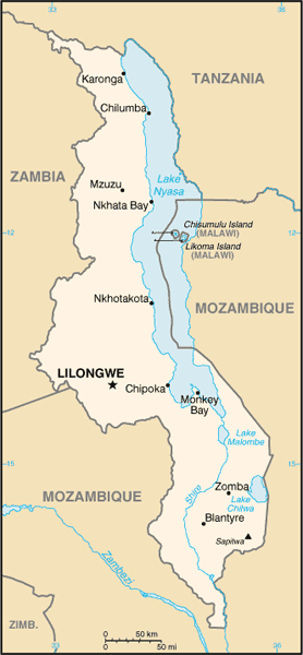
The country occupies a thin strip of land in between Zambia and Mozambique protruding southwards into Mozambique along the valley of the Shire River. In the north and north east it also shares a border with Tanzania.
The country is separated from Tanzania and Mozambique by Lake Malawi. Its capital is Lilongwe, the second largest city is Blantyre and the third largest city is Mzuzu.
The Great Rift Valley traverses the country from north to south. In this deep trough lies Lake Malawi, the third-largest lake in Africa, comprising about 20% of Malawi’s area.
The name Malawi comes from the Maravi, an old name of the Nyanja people that inhabit the area.
